


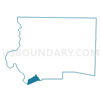
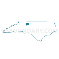
Voting District 053, Forsyth County, North Carolina
About
Outline

Summary
| Unique Area Identifier | 640008 |
| Name | Voting District 053 |
| County | Forsyth County |
| State | North Carolina |
| Area (square miles) | 4.93 |
| Land Area (square miles) | 4.89 |
| Water Area (square miles) | 0.04 |
| % of Land Area | 99.15 |
| % of Water Area | 0.85 |
| Latitude of the Internal Point | 35.99181720 |
| Longtitude of the Internal Point | -80.36916840 |
Maps

Graphs
Select a template below for downloading or customizing gragh for Voting District 053, Forsyth County, North Carolina


Neighbors
Neighoring Voting District (by Name) Neighboring Voting District on the Map
- Voting District 051, Forsyth County, NC
- Voting District 054, Forsyth County, NC
- Voting District 10, Davie County, NC
- Voting District 122, Forsyth County, NC
- Voting District 709, Forsyth County, NC
- Voting District 84, Davidson County, NC
Top 10 Neighboring County Subdivision (by Population) Neighboring County Subdivision on the Map
- Clemmonsville township, Forsyth County, NC (14,927)
- Arcadia township, Davidson County, NC (10,799)
- Shady Grove township, Davie County, NC (5,308)
- South Fork township, Forsyth County, NC (2,576)
- Hampton township, Davidson County, NC (1,282)
Top 10 Neighboring Place (by Population) Neighboring Place on the Map
Top 10 Neighboring Unified School District (by Population) Neighboring Unified School District on the Map
- Forsyth County Schools, NC (350,670)
- Davidson County Schools, NC (127,662)
- Davie County Schools, NC (41,240)
Top 10 Neighboring State Legislative District Lower Chamber (by Population) Neighboring State Legislative District Lower Chamber on the Map
- State House District 75, NC (82,603)
- State House District 80, NC (78,723)
- State House District 79, NC (74,556)
Top 10 Neighboring State Legislative District Upper Chamber (by Population) Neighboring State Legislative District Upper Chamber on the Map
- State Senate District 33, NC (189,009)
- State Senate District 34, NC (179,668)
- State Senate District 32, NC (175,441)
- State Senate District 31, NC (175,229)
Top 10 Neighboring 111th Congressional District (by Population) Neighboring 111th Congressional District on the Map
Top 10 Neighboring Census Tract (by Population) Neighboring Census Tract on the Map
- Census Tract 803, Davie County, NC (8,657)
- Census Tract 804, Davie County, NC (5,151)
- Census Tract 40.05, Forsyth County, NC (4,695)
- Census Tract 38.03, Forsyth County, NC (4,567)
- Census Tract 603.03, Davidson County, NC (4,372)
- Census Tract 38.04, Forsyth County, NC (4,100)
- Census Tract 603.02, Davidson County, NC (3,620)
- Census Tract 40.15, Forsyth County, NC (3,296)